"Using the latest remote sensing technology to achieve full coverage, closely monitoring the movements of geological disasters". Recently, the international famous journals published the results of the study of the China University of Geosciences - "integrated multi remote sensing technology to monitor the overall structure of the landslide and the latest progress", has aroused widespread concern in the international.
According to reports, China is a geological disaster occurred frequently and the disaster loss is very serious, landslide, collapse, debris flow disaster almost throughout the provinces in mountainous and hilly areas, the activity area of about 45% of the total land area. The key of the management and prediction of geological disaster is to carry on the long-term monitoring work, and the continuous and reliable ground deformation monitoring is an important content and effective method of geological disaster monitoring and early warning. Sophisticated remote sensing model is an effective way to improve the accuracy of geological disaster monitoring and comprehensive.
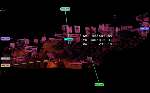
The research group using geographic information platform integrates the latest remote sensing technology, including terrestrial 3D laser scanner, GPS, aerial and satellite images, the typical landslide in Three Gorges Reservoir area and loess slope landslide comprehensive coverage and comprehensive diagnosis. The 3D laser scanner by laser active signal transmitting and receiving the laser point contact position, surface reflection intensity and color information of the point cloud data of high speed and high density acquisition can completely reflect the surface morphology of the object. Based on the high density panoramic scanning of 3D laser scanner, we can know the details of landslide deformation and the whole change, and it has broad application prospects in the landslide disaster monitoring and forecasting. The displacement of these positions can be obtained by installing the GPS at a specific location, and the deformation of the landslide can be analyzed. Technology can obtain extremely accurate subtle deformation, which can improve the accuracy of deformation monitoring. The aerial images and satellite images in different scale and scope of the whole landslide situation analysis, landslide inventory map making. Geographic information technology can effectively integrate data sources from different sensors to achieve spatial analysis and application.